A reproduction of the first-known sketch of an evolutionary tree describing the relationships among groups of organisms

“Kowloon Walled City was a largely ungoverned, densely populated settlement in Kowloon City in Hong Kong. Originally a Chinese military fort, the Walled City became an enclave after the New Territories were leased to Britain by China in 1898. Its population increased dramatically following the Japanese occupation of Hong Kong during World War II. By 1990, the Walled City contained 50,000 residents[1][2] within its 2.6-hectare (6.4-acre) borders. From the 1950s to the 1970s, it was controlled by local triads and had high rates of prostitution, gambling and drug abuse.”

“The Kowloon Walled City in Hong Kong was once the most densely populated place on earth. And without a single architect or any oversight whatsoever, the ungoverned hive of interlinking buildings became a haven for drugs, crime and prostitution. This is perhaps why the surreal, M.C. Escher-like structure, where one couldn’t even begin to imagine what life was like, captured the interest of the Japanese.”

(link fixed 2014)
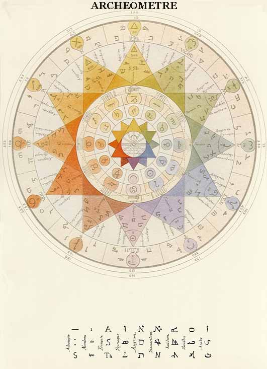
The term “Archeometre” originates from the Greek and means “the measure of the principle”. The system refers also to a series of symbols and meanings, which refer to the federal drawer.
‘Archeometre’ is it the measurement of the ‘Archee’ (Universal Cosmic Force) of which the Hermetists speaks. Is it a process, a ‘key’ which makes it possible to penetrate the Mysteries of the Word. It is a measuring instrument of the first (primary) principles of the manifested universe.
Alexandre Saint Yves d’Alveydre’s Archeometre shows the original Atlantean alphabet translates into the material the word, form, color, smell, sound and taste, the key to all religions and the sciences of antiquity.

“In the south of Brazil, in the centre of the picture, two opponent Tupi-tribes are fighting against each other. Further southward a Native American lumberjack is felling a tree for a European merchant. In the north tree-trunks are transported and a second group of natives is moving westward, accompanied by two Europeans. The Europeans are probably Frenchmen, although Brazil had been held by the Portuguese since 1500. As neither gold nor silver was found, Portuguese interest rapidly decreased, and for many years only French privateers came there after Brazilian wood.”
“This chart, displaying part of the Atlantic coast of South America, with Uruguay and the mouth of the Rio de la Plata at the top as the most southern point, and the area around Pernambuco as the most northern region, is one of the charts in an atlas that was made in Dieppe about 1538. The Dieppe cartographers were known for their reliable cartographic material, which they also presented in a very artistic way. They had excellent contacts with Portuguese cartographers, the experts *par excellence *of maritime cartography at the time. No wonder that the basic material for this atlas also came from the Portuguese: the geographical representation, the windroses indicating the points of the compass, and the spelling of the plotted place-names, all point to this origin.”
(T)