“For over 150 years scientists have tried to solve the mystery of a controversial cuneiform clay tablet that indicates the so-called Köfel’s impact event was observed in ancient times. The circular stone-cast tablet was recovered from the 650 BC underground library of King Ashurbanipal in Nineveh, Iraq in the late 19th century. Long thought to be an Assyrian tablet, computer analysis has matched it with the sky above Mesopotamia in 3300 BC and proves it to be of much more ancient Sumerian origin. The tablet is an “Astrolabe,” the earliest known astronomical instrument. It consists of a segmented, disk-shaped star chart with marked units of angle measure inscribed upon the rim.”
UPDATE:
Upon posting this item I got some feedback from internet friend and self-proclaimed Noticer Of Things, Chris Harris. Please find his updates below:
I think you can file this one under "debunked" – the landslide took place considerably earlier and was not caused by an impact. https://t.co/bEAAuGTjnn
Just been introducing the younger folk at work to some old school claymation, the work of the mighty Bruce Bickford.
“Bickford was a Vietnam veteran whose love for animation sprung out his crude home movies. His earliest experiments involved toy cars, but a need to populate these rough little films led to the creation of tiny clay figures. Soon enough he was letting his imagination spill out with strange, ever-morphing stream of consciousness tales that seemed to revolve around demons and animal heads, hamburgers and pizzas, treacherous landscapes and excessive violence – “danger and weirdness”, in Bickford’s own words. Audiences were given an early taste when The Old Grey Whistle Test aired a portion of ‘City Of Tiny Lights’ with animated accompaniment in 1979. Baby Snakes made its debut during the Christmas of that year, containing more examples and a peak of behind-the-scenes amidst the concert footage.”
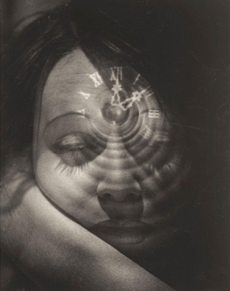
“Heinz Hajek-Halke was born in Berlin on December 1, 1898, but spent his childhood in Argentina. Back in Germany, he began to study graphics in Berlin in 1915. In 1916, he served as a soldier in World War I; thereafter he continued his studies.
Hajek-Halke began to take photographs in 1924, and soon he had work with the agency “Presse-Photo”. He experimented with photographic techniques – among them light montages, double exposures, photo collages and photo montages. One special technique is “combi-photography,” in which Hajek-Halke mounted several negatives for one print. His pictures were innovative and made use of the newly discovered possibilities for manipulating photographs.”
“Nothing surprises me much
And my hobbies include laughing in the dark
Do you wanna go to the farm? Do you wanna go to the park?
I’ll get you ice cream if you give me your card
Nothing impresses me much
I’ve got a great attitude and a map to the stars
I got your number from that sign in the lawn
I also want to vanquish evil but my mojo is gone
(I want you)
C’mon, I bet you know most of my friends
They’re some real exclusive dudes from just around the bend
They’re playing demos. Oh, they’re wearing Dries
I can escort you down the runway I just joined the police
Just right now
So you wanna be a grifter like me?
Are you hearing impaired with your own URL?
I’m the second coming, I’m the last to know,
I didn’t get invited but I know where to go”
‘Our anxiety around drawing starts around puberty, when we begin self-critiquing our abilities to render a perfect likeness, Dowd says. “The self-consciousness associated with ‘good’ drawing, or a naive form of realism, is mostly to blame,” he explains to Quartz. ”If you take a step back, and define drawing as symbolic mark-making, it’s obvious that all human beings draw. Diagrams, maps, doodles, smiley faces: These are all drawings!”’
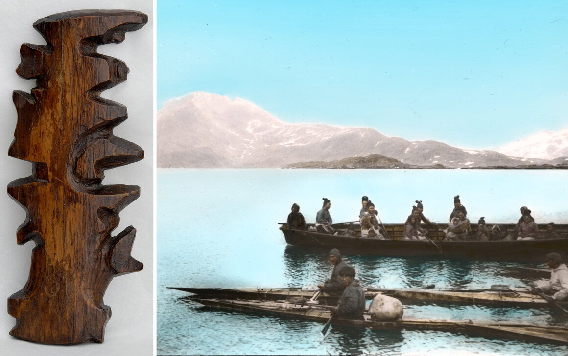
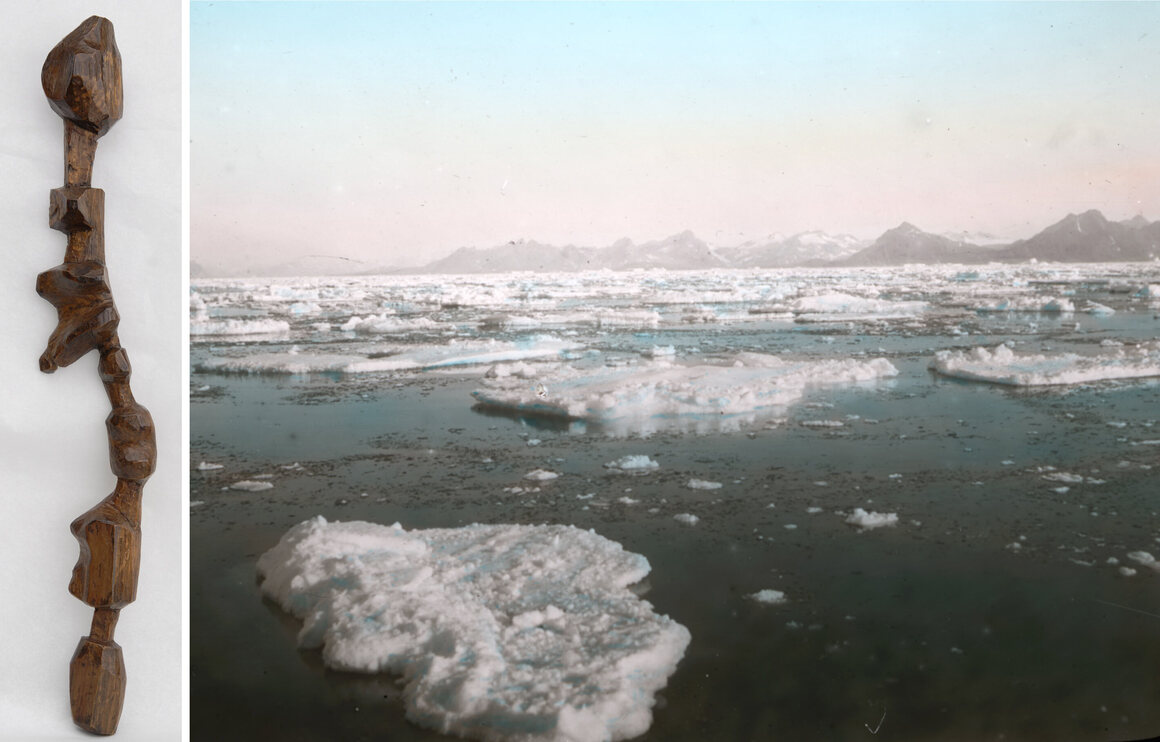
“For these seafaring people, geographic knowledge was something remembered and shared through stories and conversations of travels and hunting. “The drawing of charts and maps,” Holm wrote, “was of course quite unknown to the people of [Ammassalik], but I have often seen how clever they were as soon as they grasped the idea of our charts. A native from Sermelik, called Angmagainak, who had never had a pencil in his hand and had only once visited the East coast, drew a fine chart for me covering the whole distance from Tingmiarniut to Sermiligak, about 280 miles.” They also provided him with incredibly detailed descriptions of terrain, flora and fauna, and, in some cases, local weather patterns and lunar and solar cycles. To pass some of this knowledge on to the curious, acquisitive Holm, one hunter presented him with a set of unusual maps that have been, by turns, overlooked, discounted, misunderstood, and, eventually, admired.”
Left: a wooden map of islands off the East Greenland coast, c. 1885; Right: ice field, Ammassalik, East Greenland, 1908, by Th. N. Krabbe.
“But woodcarving was a common activity among the Tunumiit and Holm mentions that carving maps was not out of the ordinary. The Inuit people have used carvings in a certain way—to accompany stories and illustrate important information about people, places, and things. A wooden relief map, would have functioned as a storytelling device, like a drawing in the sand or snow, that could be discarded after the story was told. As geographer Robert Rundstum has noted, in Inuit tradition, the act of making a map was frequently much more important than the finished map itself. The real map always exists in one’s head. Though the maps themselves are unique, the sentiments and view of the world they represent were universal to the culture that made them.”
…Much more including annotated manipulatable 3-d models on this great post from Atlas Obscura.
“A Novel and Original Invention, by which 46,656 words or sentences can be represented with six colors, intended as A Medium of Communication between all Nations, and Applicable to any Language; also adapted to sound and night signals, by which communications may be made at all-seasons, without regard to weather.”