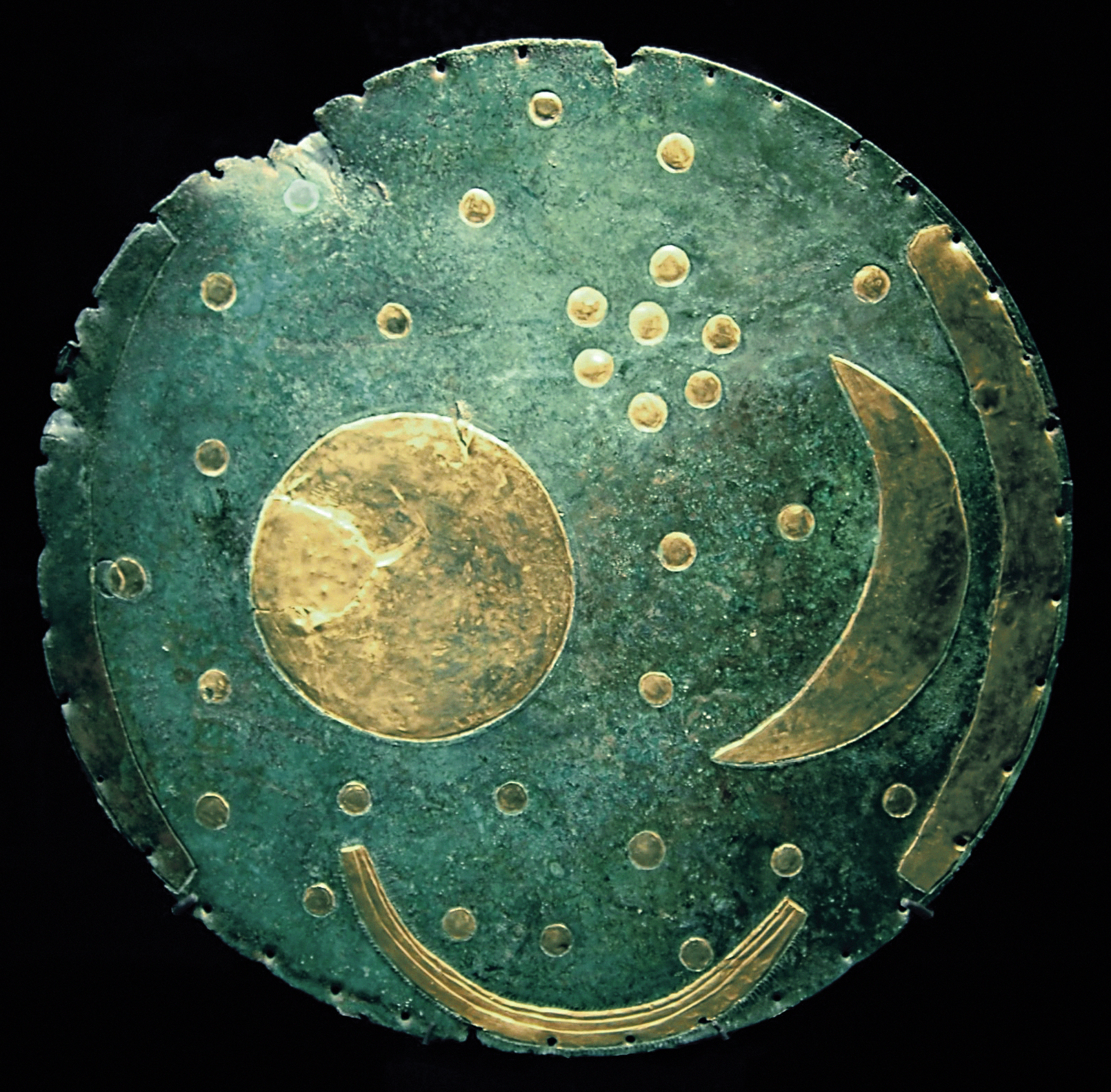
Galileo GALILEI. Autograph notes on the satellites of Jupiter, 14–25 January 1611


Galilei, Galileo, 1564-1642.

On this scrap of paper (an unfolded envelope), Galileo recorded the positions of four satellites of Jupiter over a period of several nights. He had observed the moons with the aid of his newly constructed telescope and published his findings in his revolutionary book The Starry Messenger (1610). He then worked to define more precisely the periods of the orbits of the Jovian moons, setting up his telescope night after night and making notes such as these. In a radical departure from his university training, Galileo insisted that scientific theory be grounded in observation and physical evidence rather than reliance on ancient authority.”

1856 Burritt – Huntington Chart of Comets, Star Clusters, Galaxies, and Nebulae


HTML tutorial

This rare chart of comets, star clusters and nebula was engraved W. G. Evans of New York for Burritt’s Atlas to Illustrate the Geography of the Heavens . Notes several important comets recorded in the previous 300 years including the Comet of 1689, the Comet of 1744, The Great Comet of 1680, the Great Comet of 1811, Halley’s Cement, the Great Comet of 119 and the Comet of 1843. Also shows several well known nebulas including the Horse Shoe Nebula, the Spiral Nebula and the Dumb Bell Nebula. This unusual chart appeared in the 1856 edition of Burritt’s Atlas and was not present in earlier edition.”

The Nebra Sky Disk (1600 BC)


The Nebra sky disk

The Nebra sky disk is a bronze disk of around 30 centimeters (12 in) diameter and a weight of 2.2 kilograms (4.9 lb), with a blue-green patina and inlaid with gold symbols. These are interpreted generally as a sun or full moon, a lunar crescent, and stars (including a cluster interpreted as the Pleiades). Two golden arcs along the sides, marking the angle between the solstices, were added later. A final addition was another arc at the bottom surrounded with multiple strokes (of uncertain meaning, variously interpreted as a Solar Barge with numerous oars, as the Milky Way, or as a rainbow).”

“The disk may be an astronomical instrument as well as an item of religious significance. The blue-green patina of the bronze may have been an intentional part of the original artifact. The find is regarded as reconfirming that the astronomical knowledge and abilities of the people of the European Bronze Age included close observation of the yearly course of the Sun, and the angle between its rising and setting points at summer and winter solstice. While much older earthworks and megalithic astronomical complexes such as the Goseck circle and Stonehenge had already been used to mark the solstices, the disk is the oldest known “portable instrument” to allow such measurements. Pásztor, however, sees no evidence that the disk was a practical device for solar measurements.”

via trixietreats

Tableau d’Astronomie et de Sphère

H'Atlas Universel d'Histoire et de Geographie Anciennes et Modernes, de Mythologie, des Religions, d'Astronomie, de Physique, de Geologie, de Histoire Naturelle, de Grammaire, de Rhetorique..' by Henri Duval, 1834; published in Paris by L Houbloup.
H’Atlas Universel d’Histoire et de Geographie Anciennes et Modernes, de Mythologie, des Religions, d’Astronomie, de Physique, de Geologie, de Histoire Naturelle, de Grammaire, de Rhetorique..’ by Henri Duval, 1834; published in Paris by L Houbloup.

'General Atlas Of The World: Containing Upwards Of Seventy Maps. Engraved On Steel, In The First Style Of Art, By Sidney Hall, William Hughes, F.R.G.S., &c. New Edition. Embracing All The Latest Discoveries Obtained From Government Surveys And Expeditions, Books Of Recent Travel, And Other Sources, Including The North-West Passage Discovered By H.M. Ship Investigator. With Introductory Chapters On The Geography And Statistics Of The Various Countries Of The World, And A Complete Index Of 65,000 Names' by Adam & Charles Black, Sidney Hall and William Hughes, 1854; published in Edinburgh by A & C Black.
‘General Atlas Of The World: Containing Upwards Of Seventy Maps. Engraved On Steel, In The First Style Of Art, By Sidney Hall, William Hughes, F.R.G.S., &c. New Edition. Embracing All The Latest Discoveries Obtained From Government Surveys And Expeditions, Books Of Recent Travel, And Other Sources, Including The North-West Passage Discovered By H.M. Ship Investigator. With Introductory Chapters On The Geography And Statistics Of The Various Countries Of The World, And A Complete Index Of 65,000 Names’ by Adam & Charles Black, Sidney Hall and William Hughes, 1854; published in Edinburgh by A & C Black.

A time table indicating the difference in time between the principal cities of the World and also showing their air-line distance from Washington. - 'Mitchell's New General Atlas, Containing Maps Of The Various Countries Of The World, Plans Of Cities, Etc., Embraced In Ninety-Three Quarto Maps, Forming A Series Of One Hundred and Forty-seven Maps and Plans, Together With Valuable Statistical Tables..' by Samuel Augustus Mitchell Jr, 1883; published in Philadelphia by WM Bradley.
A time table indicating the difference in time between the principal cities of the World and also showing their air-line distance from Washington. – ‘Mitchell’s New General Atlas, Containing Maps Of The Various Countries Of The World, Plans Of Cities, Etc., Embraced In Ninety-Three Quarto Maps, Forming A Series Of One Hundred and Forty-seven Maps and Plans, Together With Valuable Statistical Tables..’ by Samuel Augustus Mitchell Jr, 1883; published in Philadelphia by WM Bradley.

From BliOdyssey

Dunhuang Star Atlas


Dunhuang Star Atlas

“This ancient Chinese map of planet Earth’s northern sky is part of the Dunhuang Star Atlas, one of the most impressive documents in the history of astronomy. The oldest complete star atlas known, it dates to the years 649 to 684, discovered at the Silk Road town of Dunhuang in 1907. A recent analysis that examines the accuracy and projections used to make it notes the atlas marks positions of over 1,300 stars and outlines 257 Chinese star groups or asterisms. The star positions in the hand drawn atlas were found to be accurate to within a few degrees. In this example showing the north polar region, a very recognizable Big Dipper, part of the modern constellation Ursa Major, lies along the bottom of the chart. An additional 12 charts depicting equatorial regions in 30 degree sections also includes a group resembling the modern constellation Orion. The atlas is on display at the British Library in London to celebrate the International Year of Astronomy.”