Tableau d’Astronomie et de Sphère
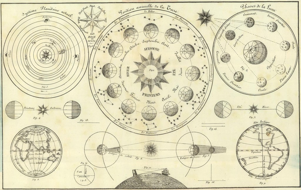
H'Atlas Universel d'Histoire et de Geographie Anciennes et Modernes, de Mythologie, des Religions, d'Astronomie, de Physique, de Geologie, de Histoire Naturelle, de Grammaire, de Rhetorique..' by Henri Duval, 1834; published in Paris by L Houbloup.
H’Atlas Universel d’Histoire et de Geographie Anciennes et Modernes, de Mythologie, des Religions, d’Astronomie, de Physique, de Geologie, de Histoire Naturelle, de Grammaire, de Rhetorique..’ by Henri Duval, 1834; published in Paris by L Houbloup.

'General Atlas Of The World: Containing Upwards Of Seventy Maps. Engraved On Steel, In The First Style Of Art, By Sidney Hall, William Hughes, F.R.G.S., &c. New Edition. Embracing All The Latest Discoveries Obtained From Government Surveys And Expeditions, Books Of Recent Travel, And Other Sources, Including The North-West Passage Discovered By H.M. Ship Investigator. With Introductory Chapters On The Geography And Statistics Of The Various Countries Of The World, And A Complete Index Of 65,000 Names' by Adam & Charles Black, Sidney Hall and William Hughes, 1854; published in Edinburgh by A & C Black.
‘General Atlas Of The World: Containing Upwards Of Seventy Maps. Engraved On Steel, In The First Style Of Art, By Sidney Hall, William Hughes, F.R.G.S., &c. New Edition. Embracing All The Latest Discoveries Obtained From Government Surveys And Expeditions, Books Of Recent Travel, And Other Sources, Including The North-West Passage Discovered By H.M. Ship Investigator. With Introductory Chapters On The Geography And Statistics Of The Various Countries Of The World, And A Complete Index Of 65,000 Names’ by Adam & Charles Black, Sidney Hall and William Hughes, 1854; published in Edinburgh by A & C Black.

A time table indicating the difference in time between the principal cities of the World and also showing their air-line distance from Washington. - 'Mitchell's New General Atlas, Containing Maps Of The Various Countries Of The World, Plans Of Cities, Etc., Embraced In Ninety-Three Quarto Maps, Forming A Series Of One Hundred and Forty-seven Maps and Plans, Together With Valuable Statistical Tables..' by Samuel Augustus Mitchell Jr, 1883; published in Philadelphia by WM Bradley.
A time table indicating the difference in time between the principal cities of the World and also showing their air-line distance from Washington. – ‘Mitchell’s New General Atlas, Containing Maps Of The Various Countries Of The World, Plans Of Cities, Etc., Embraced In Ninety-Three Quarto Maps, Forming A Series Of One Hundred and Forty-seven Maps and Plans, Together With Valuable Statistical Tables..’ by Samuel Augustus Mitchell Jr, 1883; published in Philadelphia by WM Bradley.

From BliOdyssey

“On Photography”

“It is a nostalgic time right now and photographs actively promote nostalgia. Photography is an elegiac art, a twilight art. Most subjects photographed are, just by virtue of being photographed, touched with pathos. An ugly or grotesque subject may be moving because it has been dignified by the attention of the photographer. A beautiful subject can be the object of rueful feelings, because it has aged or decayed or no longer exists. All photographs are memento mori. To take a photograph is to participate in another person’s or thing’s) mortality, vulnerability, mutability. Precisely by slicing out this moment and freezing it, all photographs testify to time’s relentless melt.”

Susan Sontag

via